-
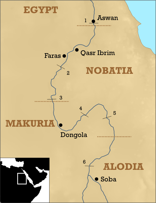
“Nubia is a historical territory that today is North Sudan and the southern part of Egypt. Generally it is assumed that Nubia covered the area along the Nile between the first and sixth Nile cataracts. Nubia formed a corridor along the Nile River, linking continental Africa and the Mediterranean. The fourth century CE brought the fall of Meroë and witnessed the birth of three kingdoms: Nobadia, Makuria, and Alwa.
Nobadia is the northernmost kingdom of this triad and spread from the first to the third Nile cataracts in its heyday. The landscape in its southern part is typical cataract scenery: barren rocky terrain almost devoid of vegetation. It was a sparsely populated area passable for river transport only at the time of high water on the Nile. The valley widened around Soleb, Wawa, Abria, and Amara, providing a considerable amount of farmland. Farther downstream, down to the second cataract, was a region called the Belly of the Rock (Batn el-Hajar), the most inhospitable part of the Nile Valley. From Wadi Halfa down to Faras lay vast agricultural lands, particularly on the western bank. Further, enclaves of farmland surrounded Arminna and Toshka. The zone between Masmas, ed-Derr, and Tumas was the most fertile and densely settled area in Nobadia. There are hardly any patches of agricultural land on both sides of the river down to Korosko, which was the point of departure for caravans traveling through the Eastern Desert to Napata, Old Dongola, and farther downstream to Abu Hamad. The next wide fertile plain suitable for extensive agriculture in Nobadia lay around Dakka, where the valley was about a mile wide. Farther to the north the valley was again inhospitable, its width tapering down to about 220 yards at Bab el-Kalabsha.
The dawn of Nobadia dates back to the end of the fourth century and coincides with the decline of the Meroitic Empire. The fall of Nobadia brought to life two competing chiefdoms: Blemmyan in the Dodekaschoinos (Dodekaschoinos is a name derived from the Greek dodekas choinos, meaning “12 miles,” that is, about 75 miles south of Aswan) and Nobadian grouped around the second Nile cataract. In circa 420, Olympiodorus of Thebes, a Roman historian, visited the Blemmyes. According to his account, despite controlling the Nile Valley, the Blemmyan king preferred to remain in the desert. At the same time the Nobades, whose royal cemeteries have been found in Qustul and Ballana, started an expansion to the north. As a result, the Nobades subdued the Dodekaschoinos and settled relations with the Byzantine Empire, which allowed for an increase in the volume of trade and an influx of new political and religious ideas. The conflict between the Blemmyes and the Nobades is attested in an inscription of Silko, the victorious Nobadian ruler, in the temple of Mandulis in Kalabsha, located at the heart of the Blemmyan territory, and in the correspondence between Aburni, one of his heirs, and the Blemmyan ruler Phonen found in Phrim (Qasr Ibrim). In the middle of the fifth century Nobades controlled the whole territory between the first and second Nile cataracts, which is called Lower Nubia. Then they directed their military expansion to the south, and in the sixth century they held sway as far south as the third cataract. The capital of Nobadia was located at Pachoras (Faras). At the beginning of the sixth century, the Nobadian elites strengthened their position within the multiethnic society, searched for effective forms for integration of the state and the people, and reached for the Christian religion. The king of Nobadia converted officially in 543.
In the so-called Nobadian period (end of the fourth century through the beginning of the eighth century CE), Nobadian territory was inhabited by various ethnic and cultural groups: the autochthonous peoples who lived in the Nile Valley in the Meroitic period (third century BCE–fourth century CE), Egyptians, settled Blemmyes, and Nobades. In the early stages of the Nobadian state formation, the official titles had ethnic epithets. Then at the beginning of the sixth century they began to be territorial, clearly indicating a transition in the state organization from ethnic to territorial. The officials recruited from the ranks of the extended royal family and local elites.
The old Meroitic religion lasted to at least the middle of the fifth century but was practiced by the local Meroitic population. We know nothing about the religion of the Nobades before they accepted Christianity in the Monophysite rite. Christianization of the peoples in Nubia did not happen overnight. It extended over time, and churches did not start to be an important element of the Nobadian landscape until about a century later. Church hierarchy developed gradually, and at the beginning there was only one bishop of the Nobades, indicating a lack of regional dioceses. Three factors spurred the economy of Nobadia in the early stages: long-distance trade of luxury goods from the African interior, widespread use of the camel, and the saqiya (a large hollow wheel with pottery jars attached to the perimeter that was used to bring up water). The camel increased the volume of trade in roadless Nubia because the weight of commodities carried by one animal was greater; the saqiya enlarged the area of land available for cultivation.
There is ambiguity about when Nobadia came to an end. The Arabic sources on the Arab incursion in Nubia in 643 and 652 do not mention Nobadia, yet other sources, such as History of the Patriarchs, cite an ongoing war between Nobadia and Makuria in the second half of the seventh century. It is certain that the two states merged into one before 707, when an inscription mentioning Merkurius, the king of Makuria, was placed in the cathedral of Pachoras.”
-Artur Obluski, Nobadia (Nobatia), in African Kingdoms by Saheed Aderinto