-
My university instructor Professor Hannah Shultz told us that maps can be important in understanding African history, so I looked at a map created in 100 CE. I wanted to see how the Ptolemies viewed ‘Kemet’ which they call ‘Aegyptos’. I was not surprised to find that the Indo-Europeans in this time period viewed ‘Aegyptos’ as being below Nubia (Ethiopia) in present-day South Sudan.
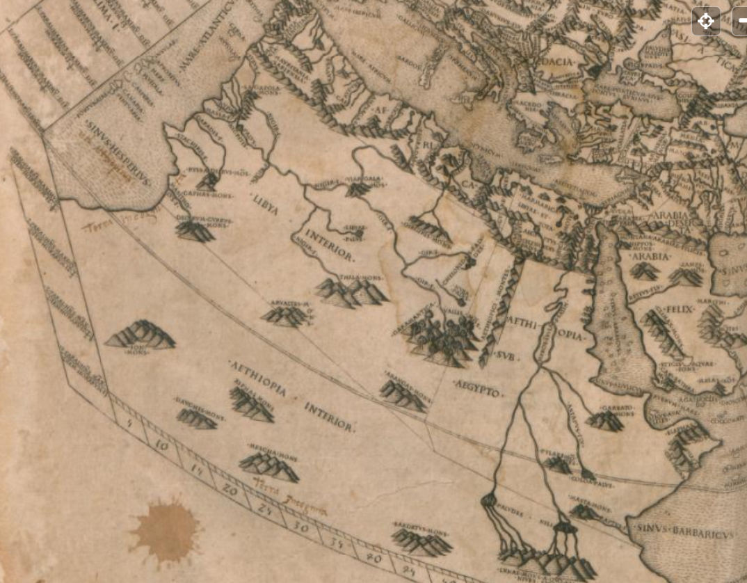
According to Ptolemy Geography Map, the European term ‘Aegypto’ which translates in English as ‘Egypt’ is located in today’s South Sudan, literally the “Land of the Blacks”. Bilad as-Sudan translates as ‘Land of the Blacks’. Clearly from this map to the right we have the Horn of Africa. On this map, the Greeks viewed Nubia as ‘Ethiopia’ along the Nile, and further south we have ‘Aegypto’ which means ‘Egypt’ located in present-day Sudan. The Greeks viewed that specific area as Egypt. The Greeks did not view the location of Egypt the same as modern geopolitical mapping blueprints of today. So, it’s very interesting to find out 1) Why was ‘Aegypto’ Egypt MOVED geopolitically from being located in today’s South Sudan region in 100 CE among the Black populations further south below Khartoum, AND now on today’s map, Egypt is located further North away from the Black populations of Sudan?(a) Why was this place named moved from the South Sudan region geopolitically?
(b) What population group, authority, or scholar is responsible for moving Egypt from the South Sudan region to the more northern regions near the Mediterranean?
(c) In what year did this take place?
So, according to my university and what they are teaching me as far as historical methodologies are that when studying the history and historical records of populations including early historical maps gives important geopolitical observations at that specific chronological time, basically, a conceptional time machine.
In the screenshot, you have a map dated to 100 CE (Common Era) from a man named Claudius Ptolemy an ‘Egyptian’ of Greek descent. His map was based on the Marinus of Tyre (c. 100 CE). Ptolemy would innovate geographical longitude and latitude lines in 8000 locations on his world map. Though you will have distortions and inaccuracies of trade routes, it is clear, that Ptomey’s geographic map was proof of the world to the East which includes Egypt, Libya, Ethiopia(Britannica:https://www.britannica.com/biography/Ptolemy/Geographer).
Britannica states
“Hence, we possess a clear and detailed image of the inhabited world as it was known to a resident of the Roman Empire at its height—a world that extended from the Shetland Islands in the north to the sources of the Nile in the south” (Britannica: https://www.britannica.com/biography/Ptolemy/Geographer).
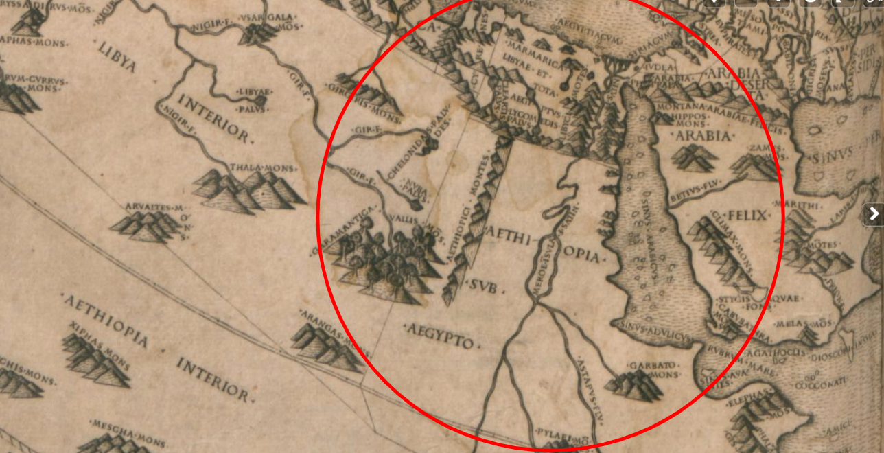
For proof of the accuracy of the Ptolemy Geographical map, Wikipedia indicates that it played an important role in the expansion of the Roman Empire. Anything that assists with civilization expansion would be of great benefit due to the accuracy of the map. Though as with all maps in that period, limitations would be evident but clearly, -Aegypto- Egypt is in the region of today’s South Sudan beneath and further south of Ethiopia-Nubia, and in between the Ethiopian interior- the Sudanic Savannah, Sahel, and further according to Greeks. This explains why Greeks described Ethiopians and Egyptians as ‘Black’, Dark skinned, or even Brown as Africans are described today. Photo B with Red Circle focuses on the area where -Aegypto- Egypt is observed directly across from the Horn of Africa nearly the location of present-day Sudan.
Wikipedia states
“The Geography and the map derived from it probably played an important role in the expansion of the Roman Empire to the East.”
(Wikipedia: https://en.wikipedia.org/wiki/Ptolemy%27s_world_map )
 2 Comments
-

Shalom Hetepu. Your observations are very interesting. Have you considered that perhaps it was not moved, but rather a primary example of Roman Hypokrisis? Since place names are crucial to understanding the human history of an area, it’s not unlikely that the dissembling or usurping of geopolitical names that indigenous African people used to identify themselves and their relationship to the land was dismissed or degraded. In the Americas this practice reached it’s apex as a tool of colonial domination.
Also, it occurs to me that the primary sources (i.e. Wikipedia, Brittanica) used to draw this conclusion originate in the white settler Cartesian epistemology: the internal ideological deception that allows the white settler to assert his thought as deed making it indistinguishable from a lie (Freud, 1959).
In fact, we will never know what place names our ancestors truly used, but we do know the significance of our relationship with community, land and Creator spirits is exemplified through naming, e.g. ren. We also know the adaptive, collective white settler neurosis that is seated firmly in the creation of it’s institutions for the sole pupose of pepetuating it’s binary worlview. I believe it’s likely that the instruction you may receive in an aforementioned institution will ultimately serve only to validate an ethos of control, approval, separation and security, as these are the primary delusions that rule white settler scholarship, along with secrecy and profiteering.
All that to say “hit dogs holler”, and white settler academia, concerning our ancestors, always sounds like hollering to me.
Are you able to substantiate these observations with primary sources from within the named places? It might provide a different conclusion. 🙏🏿🖤
-

You stated “We will never know what place names our ancestors truly used”
Your statements here are completely inaccurate. This is the purpose of historical linguistics and learning to translate the Medew Neter directly from the primary evidence, we already know the exact place names of our ‘BLACK’ ancestors along the Nile in Kemet ‘Land of the Blacks’ because we can translate and transliterate Medew Neter ourselves. For instance, the placename < tA Seti > Land of the Bow is also Kemet, and its location is elaborated on by our ancestors, we know that it was the FRONT-Land of Kemet ‘Land of the Blacks’ itself due to it being called < tA xntj > the FRONT land. For clarity, this is an ‘observation’ as we all see clearly dated to 100 CE and shouldn’t be confused with anything indigenous as this post already clarified. Also, I didn’t just use Wikipedia but also Britannica, two credible sources are given.When it comes to maps, it comes with a degree of limitations as already mentioned due to the fact it is a NON-TRADITIONAL source, this map was used for Indo-European expansion so that fact makes the map credible and accurate. We already know the indigenous names of these regions because we can translate and transliterate the old —middle—-late — including Coptic Medew Neter text ourselves. The purpose of looking at this map was already explained, we are looking at the Nile region in 100 CE, in this time period Indo-Europeans used the Greek word/placename -Aegypto- meaning ‘Egypt’ in English being located in TODAY’S South Sudan as we can see directly. This is accurate, due to tA Setj Land of the Bow called ‘NUBIA’ IS also Kemet due to the fact it’s the first Sepat of the confederation of Kemet ‘Land of the Blacks’ which is located in the same Southern region. Also, Aegypto was not used by native Kemetyw – Blacks, so this is from an Indo-European worldview that’s separate from today’s geopolitical Europeanized maps that were already explained. Again, I’m interested in the chronological changes these maps are going through, in 100 CE -Aegypto- is located between the ‘Ethiopian Interior’ and ‘the Ethiopian Nile- Nubia’ in present-day South Sudan so it’s clear that Indo-Europeans are looking at this correctly for this map fits the Medew Neter and the location of Ta Seti in the region. My interest is in WHY they changed the toponym -Aegypto- from the South Sudan location. What year did they change it? etc for further studies. Thanks for commenting.
-
-